Our Projects
Zephyr is routinely involved on the engineering design and permitting of exploration and mine development of multiple projects simultaneously. In recent years, we have been involved with the following mineral types: gold and silver. lithium, strategic minerals, iron ore, clay, limestone, diatomaceous earth, marble, and aggregates. Our technical services are preformed through Welsh Hagen Associates, a Reno, Nevada subsidiary. Our in-house property acquisition and development projects are held by Zephyr, but managed by Welsh Hagen. A newly formed subsidiary, Veterans Brigade, will be utilized as an operating company to provide On-the-Job training to military veterans to become miners and skilled equipment operators.
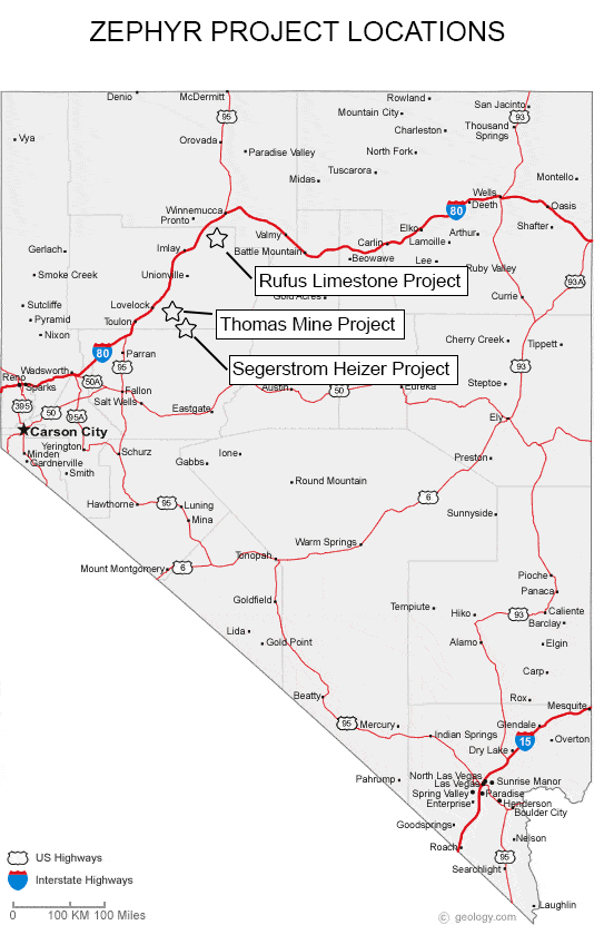
Rufus Limestone Project
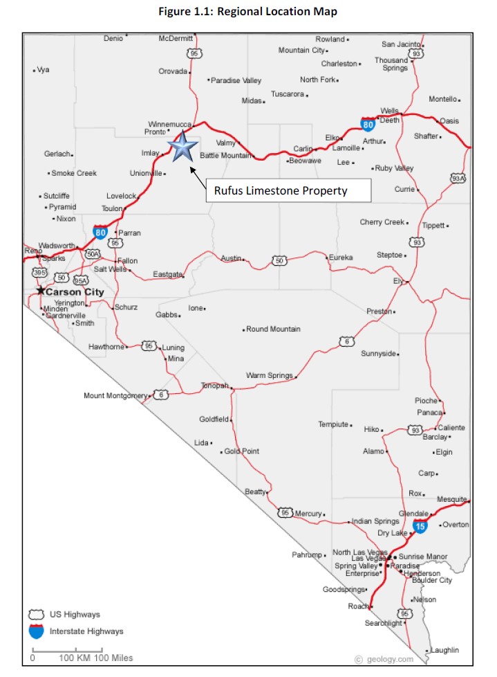
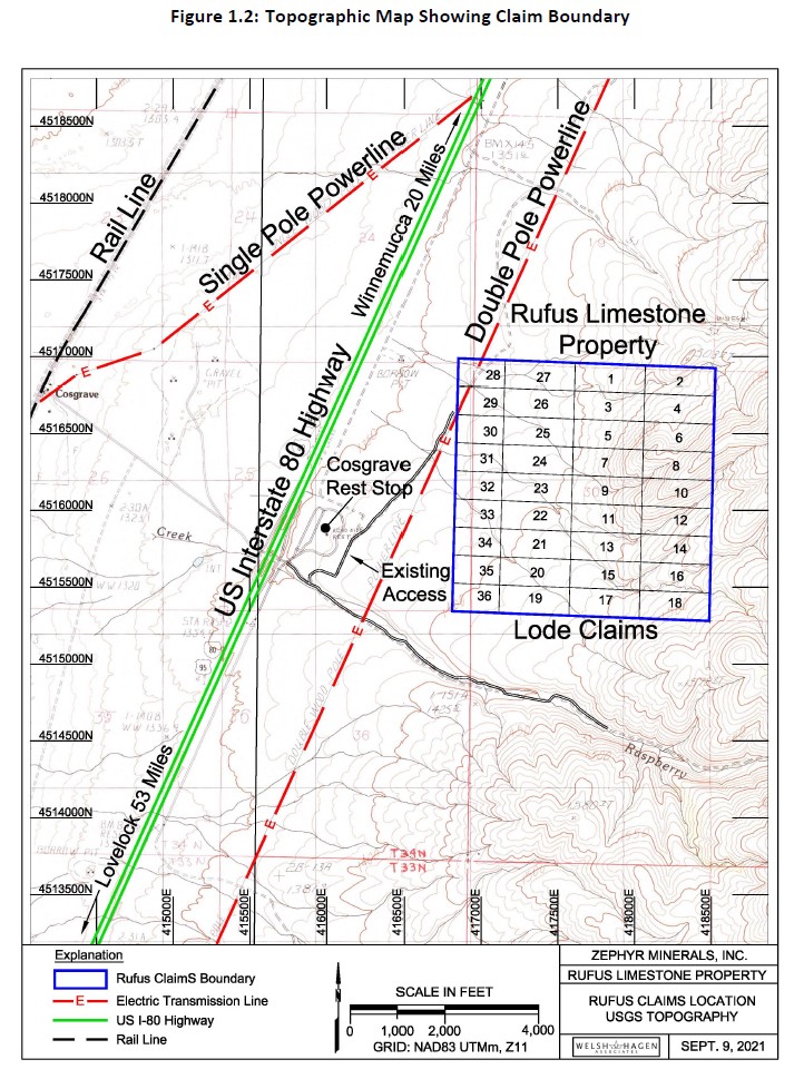
The Rufus Limestone Property consists of 36 unpatented mining claims that occupy Section 30, T34N, R36E in Pershing County, Nevada. The property was staked as a primary feedstock for cement manufacturing. By-products may include agricultural lime, neutralization media for acid mine drainage, cement block feedstock, and as additives for specific industrial materials. The deposit is located within 1.0 miles of Interstate I-80 and approximately 1.8 miles from the railroad. Grid power is available near the property. The location of the property is shown in Figures 1.1 and 1,2.
A Summary Report on the Rufus Limestone Property was prepared for Zephyr by Welsh Hagen Associates (an affiliated company) in 2019. The Report is available upon signing a Confidentiality Agreement and obtaining an electronic key to a lock box. The Report is based on surface sampling and analysis of samples performed by ALS USA Inc. of Reno, Nevada. The deposit has not been drilled to date; however a Notice of Intent for exploration drilling is planned to be filed with BLM in Q3, 2022.
Based on surface sampling and volume measurements of the above-ground exposure of the limestone, Welsh estimates that the deposit contains a potential of 50 million tons of material containing an average of 92.65% CaCO3 with an average SiO2 content of 3.13%. Since the deposit is mostly exposed, the strip ratio of waste to ore will be low. Some internal waste is expected and will be better known following drilling.
For a copy of the Welsh Summary Report, please complete this form to request a Confidentiality Agreement. Upon receipt of the signed CA, a key will be forwarded to the lock box.
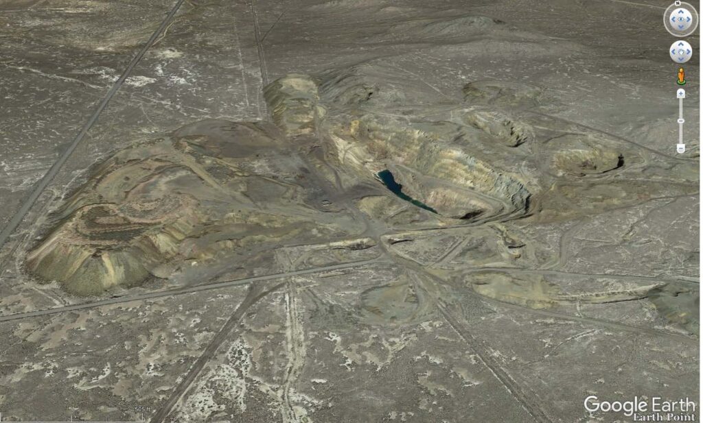
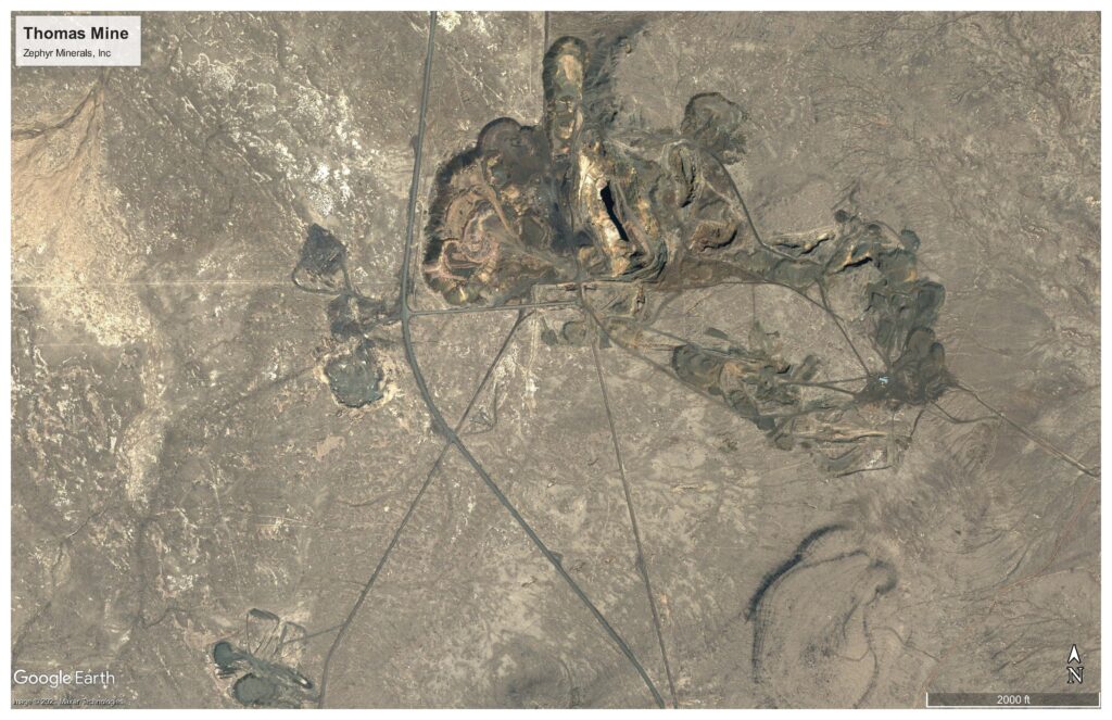
Thomas Iron Project
The Thomas mine property is a legacy iron mine located in Sections 28, 29,30, 31, and 32, T26N, R34E in Pershing County, Nevada. Access to the property is by way of Coal Canyon Road approximately 20 miles east/southeast of Lovelock, Nevada. The mineralization occurs on both private land and on unpatented claims on lands administered by BLM with most of the known mineralization occurring on private (fee) land. The existing mineralization has been loosely defined with an aeromagnetic survey conducted in 2007 by PRJ Edcon at an altitude of 75m above ground surface and a grid spacing of 75m N-S and E-W. This survey was followed with a five-hole reverse circulation drilling program in 2008 to depths of 580 feet. A mine model was constructed from the raw magnetic data by Mr. Carl Windels of Denver, Colorado using a program developed by the University of British Columbia. A Technical Report level 43-101 was written by Mr. Steven D. Craig, MS, CPG in 2009 that documents the early work performed on the property. At a cutoff grade of 10.4% Fe, the block model summarizes an inferred resource of 111,839,890 tons at an average grade of 24.6% Fe.
In 2019 Zephyr received a Nevada Division of Environmental Protection (NDEP) Water Pollution Control Permit to mine and magnetically separate up to 4 million tons of iron ore concentrate on fee land at the Thomas Mine. Zephyr is seeking funding to construct a Pilot Plant in the NW corner of Section 31 to produce a magnetic concentrate to generate cash flow while determining the crush size necessary to produce a 62.5% Fe product. Although a limited amount of grid power is available on the Thomas mine property, it will need to be supplemented with power generated on site until a larger power supply is available from a nearby geothermal supply that has been approved for construction by BLM. Zephyr has obtained sufficient water rights for dust control during mining and dry magnetic separation. Additional NDEP permits will be required before mining can begin.
Initially, the Pilot Plant is envisioned to produce 1000 metric tonnes/day with a 250 T/hr crushing plant. The initial feed will be from legacy stockpile material – supplemented with near-surface ore mined on the margins of the Thomas pit. Other legacy stockpile material may be added upon completing necessary environmental analyses to obtain permits from BLM to enter upon the unpatented claims in Sections 30 and 32. A mine model was developed by Mr. Carl Windels using the raw magnetic data and results of the drilling program. At a cutoff grade of 10.6% Fe, the estimated resource is 69,583,000 tons at an average grade of 22.7% Fe.
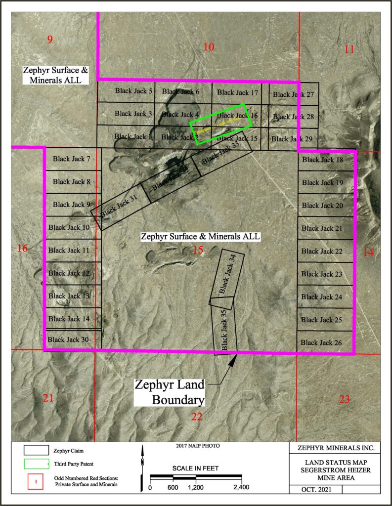
Segerstrom Heizer Cobalt Project
The Segerstrom – Heizer Mine (also referred to as SH Mine) is a legacy open pit mine that is located in Sections 9, 10, 14, 15, and 16, T25N, R34E in Pershing County, Nevada. Geographically, the SH Mine property is located approximately 3.5 miles southeast of the Thomas Mine property. Access to the property is from the Anderson Ranch Road that intersects the Coal Canyon Road approximately 1.5 miles north of the Thomas Mine. The property consists of two sections of fee land (1280 acres) and 34 unpatented claims on BLM administered land (approximately 650 acres), Historic mining was performed for iron ore between 1943 and 1966 – principally in Section 15, a fee section, however small pits were developed on BLM land in sections 10 and 16. Waste rock and low-grade material from legacy operations were placed in stockpiles on Section 10 that are now within the property package.
Mineralization at the SH Mine property was also loosely defined by the aeromagnetic survey performed by PRJ Edcon in 2007 flying at an altitude of 75m above ground surface on a grid spacing of 75m N-S and E-W. A very strong magnetic response was identified in the north half of Section 15 – trending into the southern side of Section 10. This study was followed by a three-hole reverse circulation drill program to depths of 580 feet.
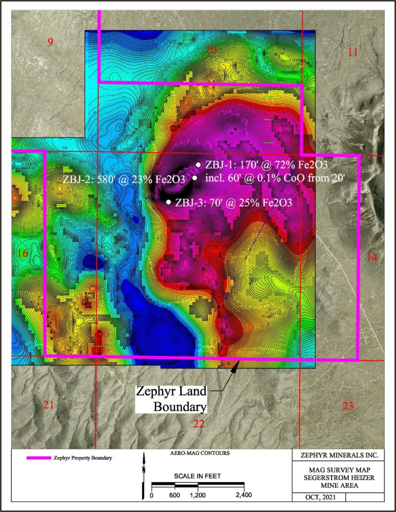
In 2017 the SH Mine property was leased to New Tech Lithium, a junior Canadian exploration company. In 2018 they changed their name to New Tech Minerals and announced that they had confirmed a discovery of cobalt on the property. The basis of their discovery was the whole rock analyses of drill cuttings from the Zephyr 2008 drill program and numerous samples of waste rock from legacy operations. A Summary Report by Dr. Kent Ausburn, PhD. PG. is available on request, subject to signing a returning a Confidentiality Agreement with Zephyr Minerals, Inc. The work to date should be considered as “preliminary” and needs to be followed up with a systematic program of drilling and assaying to determine the location and grade of the cobalt within the massive magnetite deposit.
Zephyr envisions a two-phase drilling program. The first phase will seek to define the geometry of the main mineralized fault zone that provides the aero-magnetic signature with the second phase to perform core drilling to obtain fresh mineralized material for metallurgical testing. Data from this program will become the basis for a feasibility study which will include ore resource estimates, mining costs, mineral processing costs, infrastructure costs, capital construction costs, and operating costs for mining both iron ore and cobalt simultaneously. The estimated cost of the feasibility evaluation is $2,500,000, before escalation and contingency.
For a copy of the Segerstrom Heizer Cobalt Project details, please complete this form to request a Confidentiality Agreement. Upon receipt of the signed CA, a key will be forwarded to the lock box.